


Larimar Mines on GPS Dominican Maps for Garmin & Android
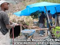
Hola, guys! I want to tell about our journey to the Larimar mines, in the same Barahona region. What is the Larimar stone? This is a kind of semiprecious mineral, was discovered in Dominican Republic years ago. It has bright-blue colour, and people develop it the southwest mountains of Sierra-de-Baoruko (2 km above the sea line). The road is a little bit destroyed, so it`s desirable using 4×4 Jeep, 4wheel, or moto-bike to access the place. dominican_republic_gps.jpg To know more about the history of dominican larimar visit Larimar Museum in Santo-Domingo. The first time dominicans knew about this stone in 1916, thanks to spanish priest who found it. Migel Mundez has found this mineral of colour of Caribbean sea which washes dominican coast. Only in 58 years appeared a few mines in Barahona. To be honest Miguel Mundez named the town of origin – Larimar. Some people live there in a small houses, and some – in the city near the hill. The stone colour from light blue to dark blue, and the surface flickers grey and white. A very interesting jewelery are represented in Larimar Museum. Address: Arz. Meriño # 452, Esq. Restauración- Zona Colonial, Santo Domingo, República Dominicana Phone (809) 686 57 00 – 682 33 09 – 688 12 05. USEFULL TIP: It`s better to buy uncut stone, and when you return to your native country, I`m sure you have a good jeweller there. Dominicans extract larimar with the most primitive way: they do mine-hole, than break basalt with hammer, and take out the breed. The Government plains to develop this sistem by the innovative technology. If you need GPS Dominican maps with track of our trip for your Garmin device – U find it easily in the signature below my post. Bueno, como ya estoy por