


Larimar Mines on GPS Dominican Maps for Garmin & Android
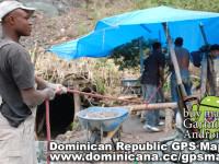
Hola, guys! I want to tell about our journey to the Larimar mines, in the same Barahona region. What is the Larimar stone? This is a kind of semiprecious mineral, was discovered in Dominican Republic years ago. It has bright-blue colour, and people develop it the southwest mountains of Sierra-de-Baoruko (2 km above the sea line). The road is a little bit destroyed, so it`s desirable using 4×4 Jeep, 4wheel, or moto-bike to access the place. dominican_republic_gps.jpg To know more about the history of dominican larimar visit Larimar Museum in Santo-Domingo. The first time dominicans knew about this stone in 1916, thanks to spanish priest who found it. Migel Mundez has found this mineral of colour of Caribbean sea which washes dominican coast. Only in 58 years appeared a few mines in Barahona. To be honest Miguel Mundez named the town of origin – Larimar. Some people live there in a small houses, and some – in the city near the hill. The stone colour from light blue to dark blue, and the surface flickers grey and white. A very interesting jewelery are represented in Larimar Museum. Address: Arz. Meriño # 452, Esq. Restauración- Zona Colonial, Santo Domingo, República Dominicana Phone (809) 686 57 00 – 682 33 09 – 688 12 05. USEFULL TIP: It`s better to buy uncut stone, and when you return to your native country, I`m sure you have a good jeweller there. Dominicans extract larimar with the most primitive way: they do mine-hole, than break basalt with hammer, and take out the breed. The Government plains to develop this sistem by the innovative technology. If you need GPS Dominican maps with track of our trip for your Garmin device – U find it easily in the signature below my post. Bueno, como ya estoy por
Dominican Republic GPS Map, travelling to Samana peninsula
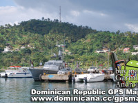
Hello, guys! Today I want to show you photos from different places on peninsula Samana (Dominican Republic). This is one of the most remarkable, mysterious and delightful places in Dominican Republic. Santa Barbara de Samana – the oldest regional center founded in 1756 for protection of piracy invasions. The road to Trujillo`s (dominican dictator) former villa, constructed on a island opposite to the port of Samana. Near of Samana there is a National Park Los Haitises which involves set of tourists with the tropical beauty. The ecosystem with too many wild islands, flying pelicans and virgin nature makes this place unforgettable. This park is famous for it`s mysterious indian caves, with a lot of petroglyphic pictures. You can see different bat species in each cave. Also you can take a cayak to ride between mangroves, or take a swim in a blue water. It is possible to visit and remarkable Caribbean treasure – small island under name Cayo Levantado – present paradise for the tourists adoring diving and snorkeling. There are many small cities on the peninsula Samana. One of them – Las Terrenas which has devoted all life to service of tourists, is especially interesting. Restaurants with fresh fish, bars, discos with sexy latin music, beaches and hotels – you can spend your time in a crazy dominican rhythm. Peninsula Samana with it`s fantastic view is very convenient for filming. Besides all the entertainments, in this small city there are many touristic guides, whom will organize any excursions, researching peninsula Samana and will show the most undercover corners, for example, some virgin uninhabited beaches like Coson or Playa Jackson. Near Las Terrenas, if you go in a direction to Samana you will see “El Limon” waterfall. Big, 30 meters height, with charming lagoon emerald color. UESFULL TIP: If it`s
GPS Maps Dominican Republic. Garmin & Android Dominican Maps. Constanza travelling
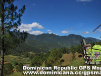
Constanza – is a city with it own history I wanted to tell you about. Several researchers found this valley in colonial times. Between the colonists was Victoriano Velano, who brought first cows and mares in 1750. In 1783 the quontity of living creatures considerably extended (cheerfully breeding). In our time the population of Constanza has aproximately 90,000 people. There are few restaurants, shops and numerous hotels with different rate. It`s interesting to see big fields with potatoes and onion. This region feeds the whole Dominican Republic. Constanza Nature is very different from the one we used to see on the coast with palm trees and ocean. USEFUL TIP: You can buy 1 package of strawberry for 1 dollar (37 pesos)! It`s really tasty. When the British consul in Santo Domingo, Robert Schomburgk has visited Constanza in 1851, he found only one manned house. 20 years later, in 1871 North American geologist William Gabb found out 12 shack in a valley. In 1887 Baron de Eggers in one of the visits to Cordilleras Centrales counted 100 persons living in 30 shacks. Till the middle of the XXth century Constanza was the valley with a small population, because of road absence. In his report Baron de Eggers also wrote that all families occupying Constanza, was living at the expense of cultivation of horses, horned livestock, beeves, “batatas”, “yucas” (tipical dominican food) and corn. Also, tobacco was the main commercial culture. Tabacco was for selling in San Juan, where was a small cigar factory. Near Constanza city there is a beautifull waterfall “Aguas Blancas”, but you can`t swim there, cause it`s dangerous. The unique access – is by jeep with 4×4. Travelling to Constanza, don`t forget to download Dominican Republic GPS Maps for Android & Garmin.